
Žilina – Krásno nad Kysucou – Stará Bystrica – Veľká Rača
- approx. 4:55 - 12:15 h
- Location: in direction to Kysuce
- Difficulty: medium difficult
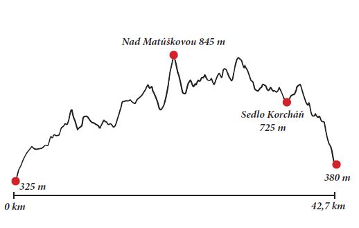
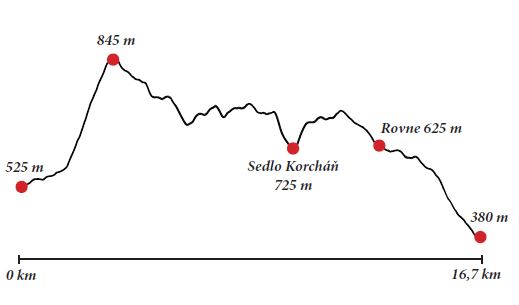
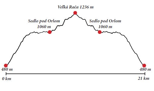
Description: You can start the red-marked trail along the Kysuce ridge in several villages in Žilina surroundings.
1/ Total time from Žilina
– Budatín to Krásno nad Kysucou: 12:15 h
Total ascent: 1,765 m / descent 1,710 m!
If you can start the trip in Žilina – Budatín it would take you more than 12 hours and we recommend it only for very well-trained hikers. You will be following the red mark all the way through. From Budatín you go to Zástranie, then to Kotrčiná Lúčka, through saddle Žiarce, saddle Jalovec and saddle below Zlieň. You can stop for a while at Zlieň (730 metres above sea level) and in 15 minutes you arrive at another saddle – saddle above Meliškovci (735 metres above sea level). You should continue along the red mark through Brehy, Pod Obelcom and through saddle Meriadov to the highest point on the trip – Nad Matúškovou (845 metres above sea level). In about 40 minutes you arrive at saddle Korcháň and in another 55 minutes at Rovné. The last section of the trail from Rovné lasts almost 2 hours, so please be ready. If you would like to make the trip shorter, you can start in Teplička nad Váhom, in Gbeľany, Zborove nad Bystricou, or in Stará Bystrica. This trip is only suitable for those who love whole-day trips, who start early in the morning and who are able to walk in terrain until the evening.
2/ Total time from Radôstka to Krásno n. Kysucou: 4:55 h
Total ascent: 690 m / 830 m descent!
A shorter variant of the above trip can be started in the village of Radôstka, where you can admire a magnificent Church of St. Andrew Svorad and Benedict. Then you should continue to local part Radôstka Krasotín (525 metres above sea level) and follow the yellow trail that starts ascending to the ridge. In 30 minutes you should arrive to Sobolčínovci (580 metres above sea level), where you can decide between a longer trail to Brehy along the yellow mark and a shorter trail through Mazúrovci along the green trail.
If you chose the shorter variant, you will get to Nad Matúšková (845 metres above sea level) in no more than one hour. Then you should continue along the red mark to saddle Korcháň (725 metres above sea level). If you are too exhausted, you can descend down to Stará Bystrica from this point. It should take you about one hour to get to the village centre. In the village you can take a bus to Rodôstka, if that’s where you have parked your car. You will get there in about 10 minutes by bus. Those who decide to continue along the ridge to Krásno nad Kysucou, have approximately 2:40 hours of hiking ahead. After the hike, you can visit the smallest Slovak gallery – the Hall of František Hübl or the Museum of National History exhibiting a life-size replica of a female mammoth. Both of them reside in the House of Culture in Krásno nad Kysucou. From Krásno nad Kysucou you can get to Žilina or to Čadca by bus or by train. You can return to Radôstka by bus, too. It will take you 30 minutes.
3/ Total time from Stará Bystrica through Saddle under Orol to Veľká Rača and back: 6:10 h
Total ascent: 996 m / 996 m descent!
Another possibility is to start the trip in Stará Bystrica (480 metres above sea level). After taking a picture of the only Slovak astronomical clock, you can start the trip along the green trail to Veľká Rača (1,236 metres above sea level). In 30 minutes you will get to Kýčera (960 metres above sea level) and then to the saddle under Orol (Pod Orlom; 1060 metres above sea level). You remain on the green trail. Now, only 40 minutes separates you from Veľká Rača. You can return by the same trail to Stará Bystrica. The trail is 21 km long and it will take you almost whole day. You can stop for a well-deserved dinner in restaurant Obľúbená in Stará Bystrica.