
Cycling trail tough 100 km
- approx. 6:00 - 9:00 h
- Difficulty: difficult
- Surface: earth 16 %, gravel 35 %, asphalt 49 %
- Total length of the cycling trail: 97.3 km
- Altitude metres: 2,301 m
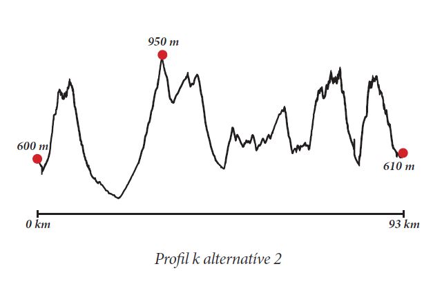
Alternative No. 2 through Koštúrov
- Total length of the cycling trail: 93 km
- Altitude metres: 2,426 m
Description:
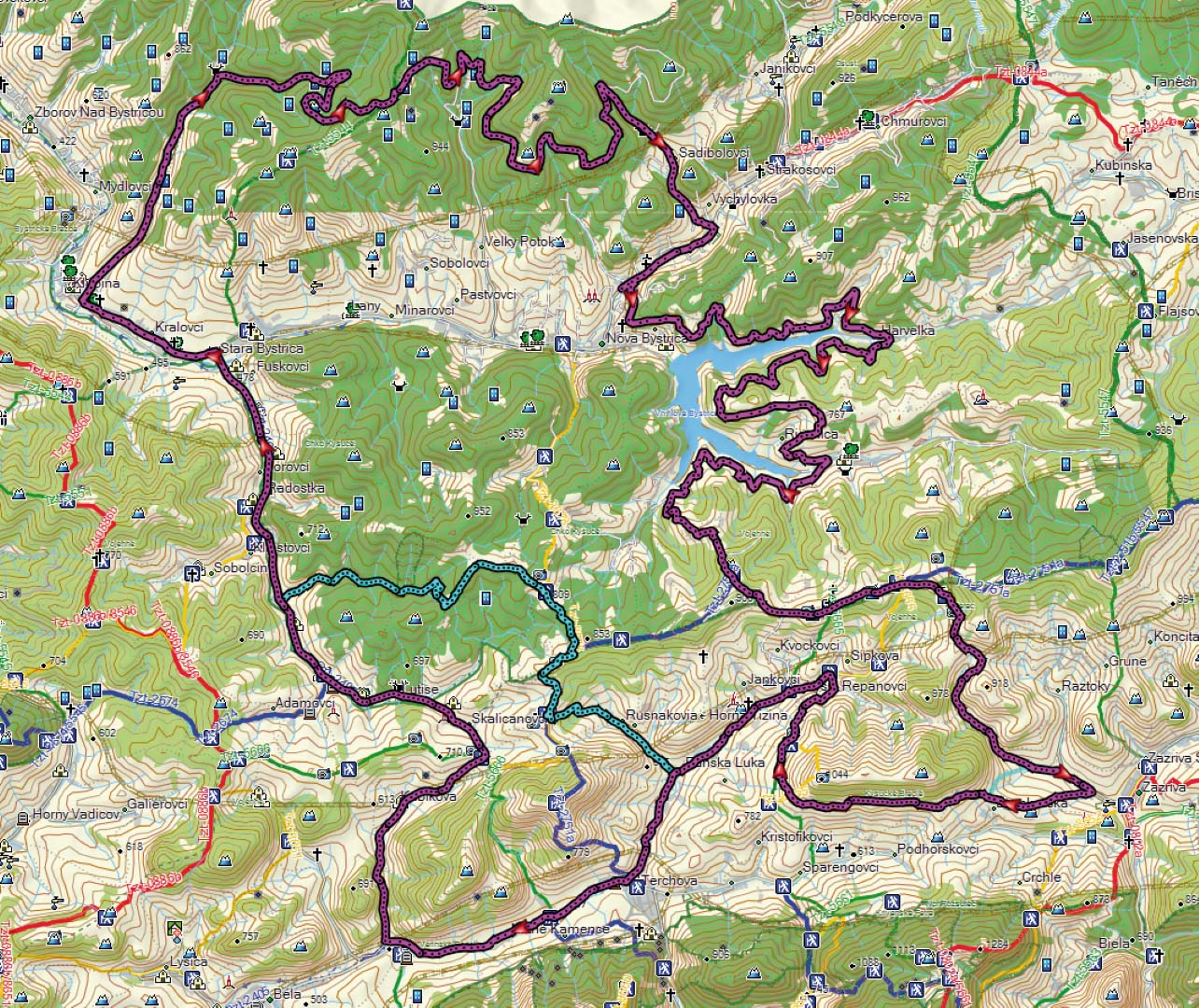
This trail is designed for sportsmen and sportswomen who would like to test their physical condition during the season. Asphalt sections interchange with gravel or earth sections and some sections go along old asphalt roads (for example around Water Reservoir Nová Bystrica) so do not look forward to a pleasant ride. This trail offers well-deserved hard work. At the beginning you should warm up a little by riding from Terchová to Stará Bystrica, approximately 25.5 km along an asphalt road with the only ascent through the saddle Lutiška. Those who do not want that much asphalt, can choose the alternative No. 2 through Koštúrov. This alternative starts with a steep ascent to settlement Káčerovci and then to the ridge Vojenné. This version is 4 km shorter, but the total ascent is + 125 m = 2,426 m! In village Radôstka you should join the cycling trail that will take you to Stará Bystrica. There you should turn left and continue along the Bystrica Cycling Artery to village Klubina. In the village you should depart from the cycling artery and turn right in direction to Klubinský potok brook. There you will start ascending to Kysuce ridges from 450 metres above sea level to 875 metres above sea level. This 10 km long ascent along an asphalt road is relatively pleasant and you should enjoy it, but it’s going to get worse. From the asphalt road you should turn right to the forest to an earthy road that will take you to the peak of Kysuce, 950 metres above sea level. The trail continues along the ridge by a relative contour line until village Vychylovka along gravel road. The downhill to Vychylovka is fast, so be careful when braking on the gravel! You can have some refreshment in Vychylovka as you have to ride for some 33 km to get into the nearest civilisation.
Around Water Reservoir Nová Bystrica through Vojenné you arrive to Zázrivá. Despite it looks as a plain trail, this section (around Water Reservoir Nová Bystrica) includes ascents and descends. The ascent from the water reservoir to the ridge through Zázvor is rather difficult (3.1 km / elevation 232 m). This section goes through meadows. From Zázvor you should continue to the left in direction to Šmehýlovci. This is the last chance to shorten your trip and to descend to Terchová if the weather is bad or if you are too exhausted. From Šmehýlovci you should continue by the green cycling trail No. 5477 along the ridge to Kováčka (cross) through Kyčerka (here the cycling trail diverts from the ridge to the right but it is still the green-marked trail) to Zázrivá.
From Rogoňovci it is a nice downhill, but you will have to climb up again soon. In Zázrivá you can choose between three versions: (1) in Zázrivá – Dolina you can continue along the green cycling trail for about 600 m / elevation 120 m, or (2) you can go another 1.1 km lower, then turn right to a field road with more moderate ascent (1.9 km / elevation 176 m). You should return to the green trail again and continue to settlement Smrekovia above Terchová. The last section (from Zázrivá to Terchová) along the green trail is rather difficult, ascents interchange with descends, even though it seems that you are going along a contour line. After arriving to settlement Smrekovia you should be happy to have survived one of the most difficult circuits in the region. From Smrekovia you only goes downhill through settlement Jánošovia to Šípková. The easiest version (3) is from Zázrivá to saddle Rovná Hora to Terchová along an asphalt road.
Marking:
Blue
No. 2424 Terchov – Zázrivá – Orava Cycling Artery
No. 2433 Klubina – Veľký Potok
No. 2434 Around Reservoir Nová Bystrica
Green
No. 5451 Vychylovka Pavelkovia
No. 5437 Káčerovci – Koštúrovci
No. 5477 Across Terchov Region
Yellow
No. 8448 Šmehýlovci – Zázvor – Reservoir Nová Bystrica
No. 8455 Saddle Melišovci – Lutiše – Koštúrovci